Balance training from 2005 to 2010
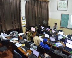
Since its inception, OSFAC provides Capacity building countries of Central Africa in Geographic Information Systems (GIS), Remote Sensing and GPS as well as technical support to all institutions that request. 869 persons, separately, from the universities (mainly the University of Kinshasa where the GIS Laboratory OSFAC is installed), national agencies, CARPE partners and international agencies have benefited from one or more training sessions with the OSFAC.
Internships
OSFAC runs a competitive internship program in GIS and remote sensing, which accepts a limited number of both academic and professional interns. Interns are accepted in a revolving fashion based on the availability of positions and are based at the OSFAC GIS/RS lab at the University of Kinshasa. The length of internships is determined individually by OSFAC depending on the intern’s proposed objectives. All OSFAC internships are unpaid.
Training modules & pricing tables
$500
per 3 days
$750
per 5 days
- Introduction to GIS (?)
- Introduction to ArcView 3
- Management of vector data
- Extensions of Arcview 3
- Presentation of information / Layout
- Tabular data management
- Creating and editing vector data
- -
$800
per 5 days
- Overview of GIS
- Basics of ArcGIS
- Applications ArcMap, ArcCatalog, ... (?)
- Working with Spatial Data
- Data Presentation / Layout
- Projection vector features
- Creation and updating of vector features
- Work with tabular data (descriptive attributes)
$1,250
per 5 days
- Introduction to Remote Sensing
- Active and passive remote sensing
- ERDAS / ENVI Menu Toolbar
- Opening and viewing an image
- Import generic formats of images
- Combination of bands
- Colored composition
- Make a mosaic
- ...
$200
per 2 days
- Introduction to GPS
- Operation
- Field applications
- GPS coordinates recovery
- ...


