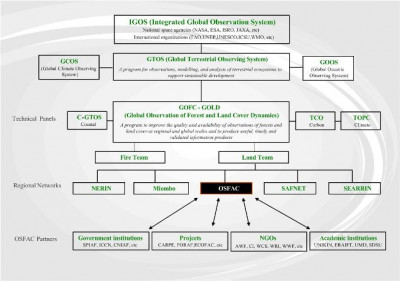
OSFAC was launched as the GOFC-GOLD network for Central Africa under the Global Terrestrial Observing System (GTOS). Its primary objective is to support the management of natural resources and promote sustainable development by producing reliable land cover products, distributing satellite data, building capacity and providing technical assistance to implementing partners.
OSFAC operates out of a head office in Kinshasa and maintains a GIS/RS lab within the School of Agronomy at the University of Kinshasa. It works in close partnership with academic and research institutions in the region, as well as, international academic and research institutions such as: the University of Maryland, South Dakota State University, the Universite catholique de Louvain and the Joint Research Center.
OSFAC’s forest monitoring activities contribute to the objectives of the Congo Basin Forest Partnership and multiple strategic areas within COMIFAC’s Convergence Plan. It receives support through USAID as part of the Central African Regional Program for the Environment (CARPE) and is also an active collaborator of the FORAF/OFAC project to establish a regional observatory that will supply decision-makers and managers reliable information on environmental and socio-economic indicators and produce regular State of the Forest reports. Through its activities, OSFAC has collaborated with many national government agencies as well as non-governmental organizations and projects, including: FORAF, WRI, ERAIFT, UN/OCHA, IUCN, WWF, WCS, CI, AWF, UNICEF, UNESCO, MAFA, and Nature+.
Since it was legally established as a Congolese NGO in 2005, OSFAC has grown and established itself as a local organization dedicated to raising awareness about satellite data and their potential applications. It serves as Central Africa’s only satellite data clearing house and as part of its partnership with CARPE, OSFAC works with regional and international academic and research institutions to produce reliable land cover products. It is committed to building regional capacity in GIS and remote sensing and offers a series of technical trainings through its lab at the University of Kinshasa and ex situ at sites across the Basin. To date OSFAC has trained over 500 individuals from over 30 different agencies in Central Africa. In addition, OSFAC has worked with a wide variety of implementing partners on mapping projects that support sustainable natural resource management and/or sustainable development.


